
Parks & Trails in SalzburgerLand
Our top trails in the regions
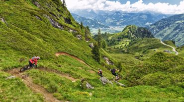
Exploring the diverse trails and parks on a freeride bike is undeniably one of the most exciting and varied activities for biking enthusiasts in SalzburgerLand. Here are our top 3 trail picks across our regions.
„SAALBACH-HINTERGLEMM“
MONTI-LINE – EASY
The trail, formerly known as the Milka Line, is a beginner-friendly and wide route stretching over 3.2 km with a vertical drop of 380 meters. It features wide turns, gentle wooden elements, small rollers, and tables that allow for first jumps—perfect for freeride beginners and kids.
DIE X_LINE AT SCHATTBERG – DIFFICULT
„THE EPIC BIKEPARK LEOGANG“
STEINBERG LINE BY FOX (SINGLE TRAIL) -EASY
A smooth, 10 km-long trail featuring easy-to-ride berms and flowing turns, offering stunning views of the Leogang Steinberge – suitable for rookies as well as pros. Nearly 1,000 vertical meters await to be conquered here.
Speedster (DOWNHILL / WORLD CHAMPIONSHIP COURSE – DIFFICULT
With a length of 2.3 km and 470 vertical meters, this track is considered the most technically demanding route – a mix of steep downhill sections, tight switchbacks, root-laced passages, and fast, flowing segments.
It also includes the new section “VALI’S HÖLLE” (0.9 km, 169 vertical meters), specifically built for the 2020 UCI Mountain Bike World Championships and named after local hero Valentina Höll. During training ahead of the final of her Elite World Championship debut in 2020, she suffered a crash here that unfortunately prevented her from competing.
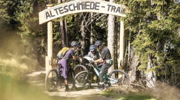
ALTE SCHMIEDE TRAIL – INTERMEDIATE
The start of the newly opened Alte Schmiede Trail is located above the Asitz summit station, from where it branches off to the right after about 350 meters. The trail, which runs outside the bike park, continues as a singletrack and occasionally offers spectacular views of the majestic Leogang Steinberge massif. It leads through untouched forest sections and alpine meadows—ideal for capturing stunning souvenir photos.
The trail offers a varied mix of flowing turns, North Shore elements, and moderately challenging technical sections, ensuring diverse and maximum riding fun. The Alte Schmiede Trail is divided into five different sections, each with its own unique character. It is open every year from June 1st to October 15th.
„BIKE ARENA FIEBERBRUNN“
SCHWEINESTBER – TRAIL I+II
The Schweinestberg Trail I takes riders on a 4 km-long route of easy difficulty, heading southeast from Streuböden over a forested ridge back down into the valley. With North Shore features, rolling sections, plenty of turns, and a wide trail layout, it guarantees a big smile for every rider!
A slightly more technically demanding experience is offered by the Schweinestberg Trail II. Covering 1 km at an intermediate level (rated red with difficulty S2), it provides an exciting challenge. The adventure also starts here at Streuböden, directly behind the reservoir, and winds up to the middle of the Schweinestberg before seamlessly connecting into Schweinestberg Trail I.
Further information at Bike Arena Fieberbrunn.
„SALZBURGER SAALACHTAL“
GRABNERALM TRAIL – INTERMEDIATE
Compact and challenging, this trail resembles the rocky paths of Lake Garda in its character—pure enjoyment in dry conditions and a demanding challenge when wet. Covering 2.5 km and 200 vertical meters, it fits perfectly as an optional section into the 26 km “Panorama Loop” around Dietrichshorn, especially as the final descent between Liedersberg and Reitbrücke.
WETTERKREUZ TRAIL SALZBURGER SAALACHTAL – INTERMEDIATE
This trail follows an old alpine path and offers unparalleled views of the Reither and Loferer Steinberge mountains. Over just under two kilometers, it descends from the Wetterkreuz, passing roots and rocks and presenting small technical challenges along the way. A “fair play” arrangement ensures that both bikers and hikers can share the new trail equally. This route is part of the 19 km Wetterkreuz Trail loop.
Further information can be found on the official website of the Salzburger Saalachtal.

„HOCHKÖNIG“
FLOW ONE (FLOWTRAIL NATRUN) – EASY
The very first MTB flow trail in the Hochkönig region guarantees pure riding fun. Stretching 3.3 km, the trail starts at the summit station of the new Natrun lift in Maria Alm and is perfectly suited for beginners and families. Even for experienced singletrack riders, the more than 300 vertical meters offer a relaxed riding experience.
FLOW TRAIL HOCHKÖNIG – EASY
The newly developed natural flow trail in Dienten am Hochkönig covers 4.2 km and descends 540 vertical meters—guaranteed action and fun for the whole family. The starting point is located below the reservoir at Bürglalm at around 1,500 meters above sea level, leading down to 950 meters at the football field in Dienten. For convenient access to Bürglalm, the Bürglalm cable car is recommended, which is also equipped for bike transport.
HANI & MARIEDL TRAIL – INTERMEDIATE
The starting point for this adventure in Dienten am Hochkönig is a relaxed ascent via the Bürglalm chairlift, which offers bike transport and stunning views of the Hochkönig. Both trails feature rooty sections and sometimes tight corners, challenging riders along the way. Between the Nani & Mariedl Trail, a short section must be pushed, creating an overall exciting intermediate trail loop. At the end, the route reaches the main road (B164) and follows the Reizegg access road back to the ski center.
„ZELL AM SEE-KAPRUN“
FLOWTRAIL MAISKOGEL – EASY
The flow trail at Maiskogel covers a total length of 4.6 km. It starts at the Maiskogel summit station at 1,570 meters above sea level and winds its way down to the Maiskogel mid-station at 1,137 meters, combining wide and tight berms, rollers, and small jumps.
GEISSSTEIN TRAIL – INTERMEDIATE
The Geißstein Trail is designed for downhill riders who love speed and prefer a flowy line rather than highly technical terrain. It starts at the Alpincenter Kitzsteinhorn at 2,450 meters and descends over roughly 3 km—half of which offers pure trail enjoyment—down to Langwiedboden at 1,978 meters. Both Langwiedboden and the Alpincenter are easily accessible via cable car, making the route particularly convenient. The trail covers a total of 3.1 km and descends 500 vertical meters.
WÜSTLAU TRAIL – DIFFICULT
The Wüstlau Trail is aimed primarily at skilled technical riders and is less focused on high speeds. It features numerous switchbacks that require precise bike handling. The route starts at Langwiedboden at 1,978 meters and descends to Wüstlau at 871 meters. Of the nearly 8 km total length, about 4 km are pure singletrack, offering an authentic and technically demanding natural riding experience. For those seeking more, the valley floor provides quick access back to the glacier lift base station at 911 meters to repeat the adventure. In total, the trail measures 7.7 km and descends 1,070 vertical meters.
Further information can be found on the Kitzsteinhorn website.
„WAGRAIN-KLEINARL“
HIRSCHLEITEN TRAIL KLEINARL – INTERMEDIATE
The trail starts around 300 vertical meters below the Kleinarler Hütte and the Kurzeggalm. What begins as a relaxed path across alpine meadows gradually turns into a demanding root-covered section in its lower part. With a length of 3 km and a vertical drop of 400 meters, the trail offers an intense riding experience. By choosing the “direct descent” into Kleinarl, the 25 km Kleinarl circuit can be significantly shortened, making this trail an attractive option for those looking to efficiently descend into the valley.
SHARED TRAIL PENKKOPF – EASY
This 2.8 km trail, with a vertical descent of 155 meters, connects the Kleinarler Hütte and Kurzeggalm.
PUMP TRAIL – EASY
Starting at the Lumberjack Hütte, this trail runs alongside the forest road down into the Kleinarltal. Along the way, riders encounter repeated short pumptrack-style rollers, ideal for practicing technique and improving bike handling skills.
Further information can be found on the Wagrain-Kleinarl website.
„GROSSARLTAL - TAL DER ALMEN“
SINGLETRAIL PANORAMA RAUSCH – INTERMEDIATE
The Panorama Rausch family flow trail, newly built in 2019, is located in the Großarltal. With its gentle average gradient of 10% and numerous bermed corners, the trail is also suitable for skilled beginners and leisure riders. At the middle station of the Kieserlbahn, it connects into the Singletrail Waldgeflüster.
SINGLETRAIL WALDGEFLÜSTER – INTERMEDIATE
Built in 2017, this trail leads from the middle station of the Kieserlbahn through forests and alpine meadows down to Großarl (3.3 km, 450 vertical meters). Together, the two trails offer 10 kilometers and 1,000 vertical meters of trail riding fun.
BIKEPARK PANORAMA
Located directly along the cycle path in Großarl, Bikepark Panorama offers an ideal environment for cycling enthusiasts. With lines of varying difficulty levels, the park is perfect for improving riding technique, learning new skills, and having fun along the way. It provides an excellent setting to develop a better feel for the bike and the trails, and to prepare optimally for singletrack rides or mountain bike tours.
Our tip for Großarltal:
E-trial park near the Alpentaverne, close to the mountain middle station.
„GASTEIN“
BERTAHOF TRAIL
The first singletrail in the Gastein Valley! The start is located near the Streitberghof between Bad Gastein and Bad Hofgastein. At the beginning, the trail descends at a moderate gradient and passes underneath the Tauern railway. It then continues through the forest with a very playful flow, offering plenty of riding fun. Towards the end, the trail becomes slightly more technical again. By the way, it finishes near the Gasteiner bathing lake. 830 m, 200 vertical meters.
More information can be found on the Gastein Valley website.